
Clearwire In Seattle + Easy Google Mapping
I’m living in a part of town that has no good option for broadband internet. That’s very annoying as in some parts of town you can get verizon fios.. and in most of the rest you can get Comcast which isn’t terrible. Where I am your big choice is a company called Broadstripe.. which is so bad even the employees blog about it. So with that I decided to try Clearwire.. the Wimax broadband provider.
(Sidenote I don’t like it when companies use names that are easily confused or otherwise in common use.. makes it very difficult to research them. So while they may call themselves ‘Clear’ now.. I’m sticking with the original Clearwire)
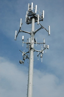
Clearwire operates a network of wireless towers to provide broadband internet (fixed or mobile) in the 2ghz range. That means their signals don’t penetrate buildings or trees very well and line of sight is best. In my case I’m going with one of their fixed wireless devices that includes an external port for a directional antenna. Where I am is technically listed as a dead zone on their map.. but I find that if I’m on the 3rd floor I get a good signal.. 4 out of 5. In periodic testing I’ve seen speeds of 4Mb down and 1Mb up in the best times and about half that in the worst times which is not bad for $50 a month in a ‘dead zone’.
Since a directional antenna could improve on that… especially when the weather is bad (and this is Seattle we are talking about) I thought it would be good to know where exactly the closest towers are so I could choose the best room placement and help aim the antenna. I did a little research and found a site that has a database of tower operators and pulled out Clearwire antenna locations all over the West and East side of Seattle. I then found a pretty slick way of taking that spreadsheet data and putting almost directly into an embedded google map. Check it out on my Project Page: Seattle Clearwire Towers The tower data is at antennasearch.com and the mapping tool is at batchgeo.com.